After spending four days in Jordan with Elaine, I spent most of our day off today with my daughter. Rachel and I drove into town and parked in in the Mamilla Shopping Center across from Jaffa Gate, where we could easily walk into the Old City. We spent a couple of hours at
the Tower of David Museum and then did the rampart walk from Jaffa Gate to Lion's Gate.
The Citadel
The Tower of David Museum is located in a fortress properly known as
the Citadel, though it is also called the Tower of David.
I had taken Elaine here back on October 10, but one of the advantages of living in an area so long and revisiting some of the sites is that one notices things that he or she missed the first time. Going to
that link will provide more background of the Citadel, and it also has several video clips that Elaine and I filmed then, including a video tour of Jerusalem from the Phasael Tower.
Jerusalem expanded onto the Western Hill across the Tyropoean Valley from the City of David and the Temple Mount at the time of Hezekiah. This area now comprises the Jewish Quarter, the Armenian Quarter, and Mount Zion. After the Babylonian Exile, Jerusalem expanded into this area again in the Hellenistic Period under the Hasmoneans, when it became known as the Upper City. This area was protected by deep valleys on most sides, except the northwestern corner was exposed, so Herod built three massive towers here to protect the city. Together they comprised a strong fortress just north of his palace, which was along the western wall of the city.
When the Romans destroyed the city in A.D. 70, they left these three towers standing, together with a section of the western wall, both to serve as a reminder of the strong city that they had taken but also to serve as the legionary camp of the Tenth Legion that they posted amidst the ruins.
 |
| Looking down into the middle of the Citadel |
When the Arabs took the city in A.D. 638, they built their own fortress on the site, using the foundations of the towers as the basis of their new citadel. Subsequent rulers of Jerusalem---the Crusaders, the Mamluks, and then the Ottoman Turks---rebuilt and modified the citadel. Though King David's Jerusalem had never extended to this area, the tall minaret of the mosque that the Turks had built in the citadel came to be known as "The Tower of David."
 |
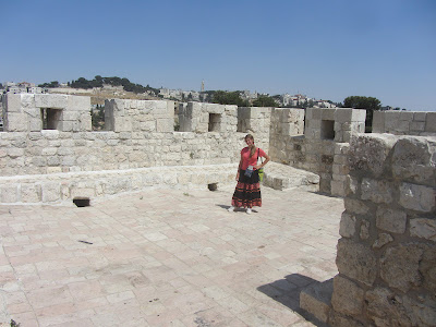
| Rachel standing at the entry to the Citadel |
 |
| This tall minaret is now known as "The Tower of David" |
 |
| Some original Herodian stones at the base of the Phasael Tower |
The modern museum in the Citadel provides a great way to learn, or review, the history of Jeruslaem. A somewhat cheesy, animated movie goes through the entire history of the city, noting each period. Exhibitions in separate rooms around te Citadel illustrate these periods: Canaanite, Israelite/Kingdom of Judah, Hellenistic, Herodian, Late Roman and Byzantine, Early Muslim, Crusader, Mamluk, Turkish, and British.
In one of the basement exhibition rooms is an interesting model of Jeruslaem made by Stefan Illes in 1878.
 |
| The model from the Mount of Olives perspective |
Climbing to the top of the tallest tower, which still bears the name of Herod's brother Phasael, affords great views of Jerusalem, both the Old City to the south, east, and north and modern Israeli West Jerusalem to the west.
 |
| Looking down at the square next to Jaffa Gate |
 |
| Looking north and west |
 |
| The Holy Sepulchre, the tower of the Church of the Redemer, and the Dome of the Rock behind me |
 |
| The domes of the Church of the Holy Sepulchre |
 |
| The Jerusalem Center appears in the background on the slopes of Mount Scopus |
The Rampart Walk
Back
on December 22, Rachel, my niece Lindsay, and I had gone on the "rampart walk" along the top of the city walls from Jaffa Gate south and then east to Dung Gate. That course comprises about 25% or so of the wall's total circuit around
the Old City. Today Rachel and I again started at Jaffa Gate but went the
other way, north and then east and then south, all the way to Lion's Gate, which is right next to the
Haram es-Sharif or Temple Mount.
This walk allowed us to see a lot of familiar sites and locations from a different perspective, for instance, looking down on both sides of Damascus Gate. Rachel also discovered a panorama feature on our small red camera, so I have included a number of those shots below as well.
The panoramas can only appear so large on the blog, but if you click them, you can view them in a much larger size.
 |
| Looking back at Jaffa Gate |
 |
| The Municipal Building(s) across from the northwest corner of the walls |
 |
| This surprising garden was right next to the rampart |
 |
| Looking down on the square outside of Damascus Gate |
 |
| El Wad stretching out behind Damascus Gate |
 |
| "Skull Hill" and the bus station in front of it from a different perspective |
 |
| Panorama from above Damascus Gate (don't forget to click to enlarge!) |
 |
| Police station and post office off of Salah-e-Din |
 |
| Rachel in the "Stork's Nest," the northeast corner tower |
 |
| The Rockefeller from the Stork's Nest. In the final days of the 1967 War, Israeli troops held the Rockefeller while Jordanians fired across at them from the Stork's Nest. |
 |
| Just inside the corner of the wall . . . a soccer field! |
 |
| Panorama from the Stork's Nest, looking south |
 |
| View from the Stork's Nest |
 |
| I wish that this panorama of the Mount of Olives could be much larger . . . but still click it to see it the best you can! |
 |
| Basilica of the Agony and Church of Mary Magdalene on the Mount of Olives |
 |
| Looking up the Via Dolorosa from Lion's Gate |

 |
| End of the line: the rampart walk ends at a wall of Herodian Stones next to the Temple Mount |
 |
| We came down from the rampart walk at Lion's Gate |
Walking Back through the Old City
 |
| Panorama around the Citadel towards Jaffa Gate |


Looked at this with our kids. Great memories. Love the panoramas.
ReplyDelete