Today (1/9/12) we took our students on our first out-of-center field trip (they went on orientation walks last Thursday, but this is the first time we got them on a bus and took them to specific sites for the full treatment--reviewing the archaeology and history, reading pertinent scriptures, and often singing). It is called the "Jerusalem Overlook" field trip because it consists mostly of sites around the city that give a good view of Jerusalem and the surrounding territory.
Note: Because I am now on my "second round" of all these sites, blog entries will usually not include as much historical background and other discussion. Instead I will usually start an entry with a link to the last time we visited that particular site, and I will then post pictures of this group of students at that site. However, my entry for last semester's overlook field trip was rather incomplete, and we went to a couple of places this time that we did not then . . . so hang on for a full entry once again this time.
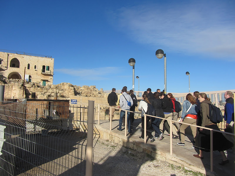
The first site we went to today was Nabi Samwil, which is the traditional "Tomb of the Prophet Samuel north of Jerusalem. Probably originally the "High Place" above the site of biblical Gideon, the Byzantines later established a monastery here, which they associated with the resting place of Samuel, even though that was actually in Rama, somewhat to the north and west. Later the Crusaders called the height Mont de Joie built a large castle here because it afforded them their first view of Jerusalem. The site dominates the approach to Jerusalem from the Ayalon Valley to the north, so the Crusaders built a strong castle here.
 |
| The mosque at Nabi Samwil |
 |
| Crusader ruins at Nabi Samwil |
In 1730 the church of this castle was incorporated the village mosque, and since Islam venerates Samuel as an important prophet, they still honor him with a cenotaph (an empty, honorary tomb) in this mosque. When Israel took the hill top in 1967, they opened a small Jewish synagogue in the basement, where a second cenotaph was established. The mosque was not open to our students, but we did briefly visit the Jewish prayer room, with the men going on one side and the women on the other per orthodox Jewish practice.
 |
| The entrance to the mosque. |
 |
| An interesting feature of synagogues and Jewish shrines is that they are places of study as well as prayer and worship. They almost have the appearance of libraries. |
 |
| The cenotaph of Samuel |
After we exited the building, we went to the north brim of the hill, which afforded us a view of the Benjamin Plateau, including the village of Al-Jib immediately below, the name of which reveals its origins as the Old Testament town of
Gibeon. My colleague Jared Ludlow discussed the geography and what we could see from that position, after which I reviewed pertinent biblical passages, including the miracle of the sun standing still at the time of the Israelite invasion (Joshua 10:6-14), and Solomon's prayer for wisdom at the high place were we were standing (1 Kings 3:3-4). But I spent most of our devotional talking about the prophet Samuel, recalling his miraculous conception and birth, his call from the Lord as a child, his judgeship, and his role in anointing first Saul and then David as king of Israel. That gave me a chance to testify of the role of prophets, after which we sang "We Listen to a Prophet's Voice" (hymn 22).
 |
| The view north from Nabi Samwil towards the Benjamen Plateau |
 |
| Al-Jib, the biblical Gibeon |
 |
| My class at Nabi Samwil |
Our next stop was
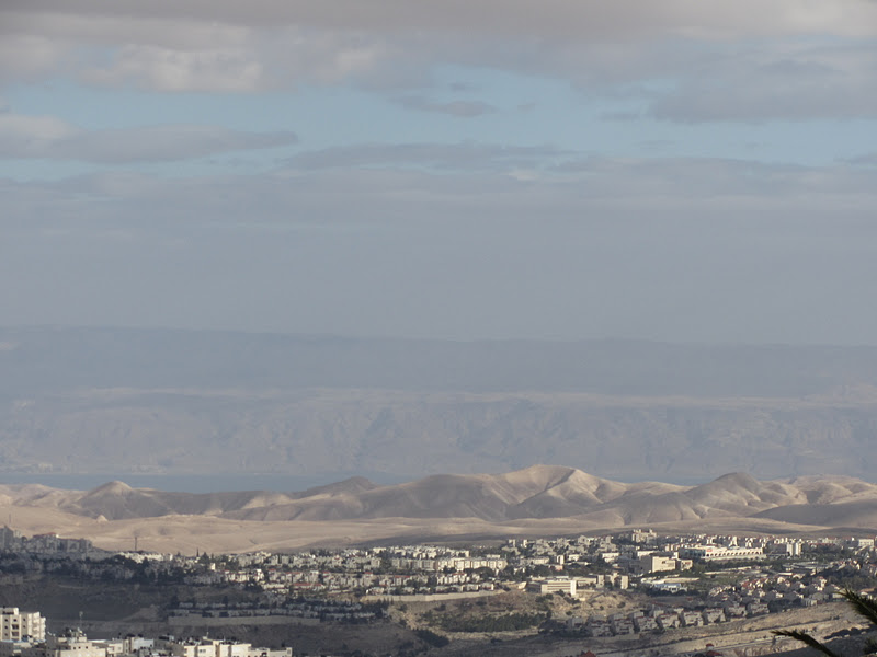
the church and tower at Augusta Victoria, the Lutheran church on Mount Scopus just south and east of the BYU Jerusalem Center. The tower affords good views in all four directions, so Jared took half the students up the tower to look west to Jerusalem, south to Bethany and the Herodion beyond Bethlehem, and east to the Judean Wilderness, the Jordan River, and the Dead Sea. Meanwhile, I kept the students in the sanctuary and taught them how to "read" a church, noting the different standard parts of a Catholic or Protestant church. Then, to honor Martin Luther, we sang "A Mighty Fortress Is Our God" (hymn 68), after which we also sang "All Creatures of Our God and King" (hymn 62). After discussing the importance of the nearby Mount of Olives in the ministry of Jesus and its role at his future return, we sang one of my favorites, "All Glory, Laud, and Honor" hymn 69), which got me excited at the prospect of spending Holy Week here this year.
 |
| Augusta Victoria, completed in 1910 by Kaiser Wilhelm II and named after his wife |
 |
| The interior of the Augusta Victoria church |
 |
| Half of the students singing in the sanctuary |
 |
| The organ in the gallery of the back of the sanctuary |
 |
| Urbs Sancta Jerusalem: the holy city of Jerusalem |
Our next stop,
the Seven Arches Overlook, has no historical or religious significance on its own, but it provides one of the best views of the Old City and especially the Temple Mount as well as the cemeteries below it on the Temple Mount. This was exciting for the students since it afforded the students their first really good look at the Old City.
 |
| Jared teaching |
 |
| The blue-gray domes of the Church of the Holy Sepulchre are just to the left of the golden Dome of the Rock |
 |
| The view south of the Old City |
 |
| Jewish graves on the Mount of Olives |
We then drove south, almost to Bethlehem, to
Mar Elyas, a Greek Orthodox monastery that provides a good southern view. After pointing out some "political geography," such as the Israeli settlement of Har Homa juxtoposed to the Palestinian modern city of
Bethlehem, we talked about the Way of the Patriarchs of "Ridge Route," as well as Joseph and Mary's arrival in the biblical town of Bethlehem that fateful first Christmas. And even though Christmas is over, we sang Christmas carols nonetheless!
 |
| Mar Elyas, or "St. Elijah" |
 |
| My class with Bethlehem in the background |
 |
| Students singing Christmas carols |
 |
| An open hillside like the one that we often use as our "Shepherds Field" |
Driving back to Jerusalem, we stopped at
the Haas Promenade, which gives the first view of Jerusalem when approaching from the south. After I explained the geography, Jared reviewed the story of Abraham bringing Isaac to Mount Moriah, purportedly to sacrifice him (Genesis 22:1-6, n.b. v. 4, "Abraham lifted up his eyes and saw the place afar off.") and movingly compared the story to the sacrifice of Jesus Christ. I followed by talking about how the sacrifice of Christ had removed all enmity between us and God so that we never need fear approach him again, the temple no longer being so much a place of sacrifice but a place of joy and communion. We then sang, "Beautiful Zion Built Above" (hymn 44).
 |
| Jerusalem from the south |
That officially ended our Overlook field trip, but we had one more stop before we went home. The bus let us off at
Hebrew University, just north and west of our BYU Center. The purpose was to familiarize the students with the bus and computer services available at the university, but it also afforded some good views itself.
 |
| Newer buildings . . . |
 |
| . . . and older buildings |
 |
| View to the west from the Rothenberg Amphitheater |
 |
| lose up of the western view through the Judean Wilderness to the Jordan Valley and the Jordanian highlands beyond |
 |
| View of the city from the Mount Scopus campus of the Hebrew University |
 |
| And a view of our center next door! |


Thank you, thank you! I am thoroughly enjoying your photos and descriptions. We have our son's semester itinerary posted at home, and it is great to be able to follow along with your blog, and his. We appreciate your dedication, and the efforts of the other teachers, in sharing the Holy Land with the students, and us (via your blog).
ReplyDeleteWe truly appreciate the pictures you post and your narrative. It is good to see the sites and see our daughter and the others. Thank you for your speed in posting here!
ReplyDeleteHunts. Nice glasses. Don't forget who your favorite students are. Miss ya.
ReplyDelete